

Loading panorama viewer ...
Configuring ...
© 2008 Wim Gombeer, All Rights Reserved.
Caption
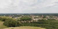
Standing on top (100m) of the slag heap (in Flemish: "terril" or "tris") of Beringen you can enjoy this 360° view of the province Limburg (East) and parts of the Provinces Antwerp (West) and Brabant (South-West).
These "mountains" are the remains of the coal mining industry that gave economic & social life shape in Limburg. You can see the other mines and heaps in the panorama to the East (Heusden-Zolder, Houthalen, Winterslag, Waterschei & Zwartberg). The Beringen coalmine started production quite late in 1922 due to engineering problems (water breaking in); On October 28, 1989 it closed its doors after a total production of 79.332.000 tons !! . The remaining slag heaps and mining buildings are still very obvious around the city.The mining museum (an Anchor Point of ERIH, The European Route of Industrial Heritage) is one of Beringen’s main attractions, retracing the industrial history of the region.
Location
Lat: 51° 4' 21.12" N
Long: 5° 14' 5.95" E
Elevation: 100m
Precision is: High. Pinpoints the exact spot.
Equipment
Nikon D300 with AF16-85mm f3.5-5.6 VR on Seitz VR-drive - PTgui - Cubicconverter - Adobe Photoshop.
 Tap or click the zoom icon in the bottom right corner of the picture to switch between in-page and fullscreen view