

Loading panorama viewer ...
Configuring ...
© 2009 Piotr Popik, All Rights Reserved.
Caption
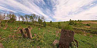
The Jewish cemetery in Lutowiska is situated on the hill, 400 meters eastwards from the town, near the bank of the Smolnik river. It is one of the biggest necropolises in the Bieszczady Mountains area. Up to now only 100 tombstones have survived. The oldest matzeva dates back to the year 1796.
Location
Lat: 49° 14' 59.56" N
Long: 22° 41' 57.48" E
Precision is: Medium. Nearby, but not to the last decimal.
Equipment
The panorama was taken with Peleng MC f 3.5/8 mm lens (set at f 8, ~ 1.5 m) on Canon EOS 20D camera, (set at: 1/500), ISO 200). The panorama was stitched with 5 images (4 around plus zenith) using Professor’s Helmut Dersch Panorama Tools (PTGui 4.1 graphical interface). Autopano and Enblend, as well as Gimp's ability to create Text Circle Logo were all of great help. I used 8-bit source images. Equirectangular image was converted to Quicktime with a registered version of Pano2QTVR Pro 1.6.2.
 Tap or click the zoom icon in the bottom right corner of the picture to switch between in-page and fullscreen view