

Loading panorama viewer ...
Configuring ...
© 2004 Christian Braut, All Rights Reserved.
Caption
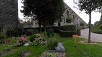
To supply water for the garden and stepped cascades of the Versailles castle, the "Sun King" Louis XIV asked the french engineer Arnold de Ville to build the "machine" of Marly and the Louveciennes Aqueduct. Inaugurated in June 1684, the "machine" of Marly carried water from the Seine to Versailles via the Louveciennes Aqueduct.
Equipment
Taken with an Nikon Coolpix 8700 with WC-E63 wide angle, f.2.8 at 1/9 second. Mounted on a Manfrotto SP303PLUS Head. Stitched with Realviz.
 Tap or click the zoom icon in the bottom right corner of the picture to switch between in-page and fullscreen view