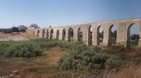

Kamares Aqueduct, Larnaka. Cyprus.
Larnaka, Cyprus
12:00 local time (=10:00 GMT) 19/09/04

Loading panorama viewer ...
Configuring ...
© 2004 Norma Boylan, All Rights Reserved.
Caption
Kamares area on the Larnaka - Lemesos road.A beautiful 18th century aqueduct which was built in 1745 in the Roman style to carry water from a source about 6 miles south of Larnaca into the town to provide Larnaca with water. It surfaces in a gully along the highway to Limassol and was still in use until 1930 supplying water to the city of Larnaka.
There are more than 20 arches still intact, remnants of others can be found to the south of the town
Equipment
Taken with a
Kodak DX3900, digital camera, at the equivalent of 35 mm.
Mounted on a tripod but without any pano-head. Stitched with VRWorx 2.5
 Tap or click the zoom icon in the bottom right corner of the picture to switch between in-page and fullscreen view