
Ants - Mighty Transporters in the Forest
Beneath Bärenjoch Peak, Tyrol, Austria
September 23, 2006 - 07:30 UTC (08:30 local time)

Loading panorama viewer ...
Configuring ...
© 2006 Carl von Einem, All Rights Reserved.
Caption
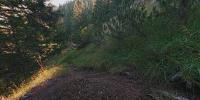
While I transported my backpack right across the spot where I shot my "Borders" panorama heading for the peak of the Hinteres Sonnwendjoch together with Markus we found this ant-hill in the first sun light shining through the mountain forest touching the trees. The morning mist was just behind us in the valley.We often tend to overlook the small things in life. Wood ants are a particularly small example of transportation device but let us stumble over their home every now and then. They build hills as their homes and if they find a nice sunny spot for it with enough building material around they feel at home even if it's just right in the middle of a path used by some early hikers who want to reach the mountain's peak.
Ants are extremely busy during working hours and so I had no chance to freeze some of them during my exposure time of 1 second. There is one dark blurred spot on the stone right at the bottom (aka nadir) of the panorama and I assume this is one of them caught while sun bathing. A worker ant is able to carry up to 40 times of its own weight, so maybe the ant on the stone is just trying to carry it out of the way...
Most of those ant populations who build hills are protected by law because their states are fragile systems and they are extremely important for the forests' ecosystem. They put much energy in keeping their home tidy and for this reason they dig the whole hill up every two weeks. See the links to Wikipedia at the bottom for more information.
During that day Markus and I found about a dozen ant hills in that area.
- See a photo of the place where I shot my panorama for the Borders event in summer and other related photos of that day in the Bavarian / Tyrolean Alps
Location
Lat: 47° 35' 59.5" N
Long: 11° 54' 46.9" E
Elevation: 1.576 m (5.170 ft)
Precision is: High. Pinpoints the exact spot.
Equipment
- Voigtländer Bessa-L / 12 mm (rectilinear) ultra wide angle lens, Fuji Reala, Novoflex customised panoramic head and BasicBall mini tripod
- Nikon LS-4000 with Silverfast scanning software
- Photoshop, CubicConverter, VRPrep AppleScript (Thanks, Landis!)
 Tap or click the zoom icon in the bottom right corner of the picture to switch between in-page and fullscreen view