
"In Town, Without My Car!"
Montréal, Québec, Canada
September 22nd, 2006 - around 1:30 pm local time

Loading panorama viewer ...
Configuring ...
© 2006 Eduardo Hutter, All Rights Reserved.
Caption
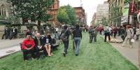
The International Car Free Day was celebrated on september 22nd in Montreal where several downtown streets were closed to cars, buses, trucks, etc.
Ste-Catherine st - one of the main downtown streets - was covered with a grass layer and the usual workers that normally struggle with pollution and heavy traffic on their lunchtime, could reclaim that space.
Currently, 80% of the total fuel consumption is used by road transports which are also responsible for over 40% of suspended particles emissions and the main cause of air and sound pollution in the urban environment.
Bringing together 2200 participant and associated cities in 38 countries, the "In town, without my car!" campaign is an opportunity to test public policies and alternative forms of transport and also a moment for us to reevaluate our habits.
"Na cidade, sem meu carro!"
Dia internacional sem carro
O Dia Internacional Sem Carro foi celebrado no dia 22 de setembro em Montreal onde várias ruas do centro da cidade foram fechadas à circulação de carros, ônibus, caminhões, etc.
A rua Ste-Catherine - uma das principais do centro - foi coberta por uma camada de grama e os trabalhadores que durante o horário do almoço sofrem com o tráfego opressivo e a poluição, reconquistaram este espaço.
Atualmente, 80% do consumo total de combustível é usado no transporte rodoviário, responsável por mais de 40% das emissões de partículas poluentes e a principal causa de poluição do ar e sonora no meio urbano.
A campanha internacional "Na cidade, sem meu carro!" - promovida no Brasil pela ONG Rua Viva - põe juntas 2200 cidades participantes ou associadas em 38 países, é uma oportunidade para testar políticas públicas e meios alternativos de transporte e talvez mais importante que isto, uma oportunidade para cada um de nós reavaliar nossos hábitos.
Location
Lat: 45° 30' 11.86" N
Long: 74° 35' 10.9" W
Elevation: 0
Precision is: High. Pinpoints the exact spot.
Equipment
Nikon FE2 with a Zenitar 16mm f/2.8 lens, NodalNinja panohead, Fuji Reala 100 negative film (yes, there's still some people that uses real, palpable film!). Stitched with PTGui, post-processing with Photoshop and converted to cubic using Pano2QTVR.
 Tap or click the zoom icon in the bottom right corner of the picture to switch between in-page and fullscreen view