

Loading panorama viewer ...
Configuring ...
© 2006 Erik Krause, All Rights Reserved.
Caption
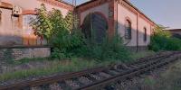
Only a few hundred meters from my home is the the old goods railway station of Freiburg. It will soon be torn down to make room for new flats and offices. I hope they will preserve at least a bit of the old architecture.Currently the warehouses are still used to store goods and are also used as studios, small factories and workshops.
The trains, however, don't use this spur any more and only the names of the streets like "Zollhallenstraße" (toll street) or "Freiladestraße" (free-goods street) tell of the former importance when there was still customs at the border to France.
More panos from the old goods station at my page
Location
Lat: 48° 0' 50.85" N
Long: 7° 50' 57.31" E
Elevation: 250m
Precision is: High. Pinpoints the exact spot.
Equipment
Canon EOS 600, Fuji Reala, scanned with Nikon LS40, stitched with PTGui and smartblend.
 Tap or click the zoom icon in the bottom right corner of the picture to switch between in-page and fullscreen view