

Loading panorama viewer ...
Configuring ...
© 2006 Erik Van den Broeck, All Rights Reserved.
Caption
Belgium with Holland is sometimes described as the 'lowlands', we have no mountains, the highest point is about 600 meters.
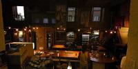
From Kortrijk it's over 200 km to find a place to practice climbing if it was not for http://www.blueberry-hill.be, this adventure sport centre houses a 13 meter wall with varying difficulties from easy to hard depending on the place on the wall and the colour of grips/support used.
Enjoy!
Location
Lat: 50° 49' 13" N
Long: 3° 17' 33" E
Elevation: 19
Precision is: Medium. Nearby, but not to the last decimal.
Equipment
Hardware:- camera - Nikon D50
- lens - Nikon 10.5mm F2.8
- bracket - Nodal Ninja 3
6 roundshots at 1600 ASA F8 1/15s
Software:
- stitcher - PTGUI
- cubic converter - Pano2QTVR
- editor - Photoshop CS2 & Paint Shop Pro 9
Behind the scene : how this panorama was made
This is my first pano with my new D50 and 10.5mm F2.8 lens, coming home I noticed I used 1600 ISO but on a closer look this was no mistake as I needed 1/15s to use F8, being there the place look’s well lit but with these lights that's a false impression.
Also notice the 3 types of light, so used the sunny setting to get natural colours.
Also a first for me is the use of a 3 meter pole, the camera cannot be reached and the IR remote did not work without being in the pictures until I sticked on a paper reflector next to the receiver.
And yes there are errors, some ropes are diconnected but these are no stitsching errors, I just could not ask the climbers to hang there for a couple of minutes, so got errors between the roundshots and the upshot, I did not even try to correct them in PS due to the complicated backdrop.
 Tap or click the zoom icon in the bottom right corner of the picture to switch between in-page and fullscreen view