
Crossing the River...
Bremen-Vegesack, Germany
September, 22 2006 at 16:16 local time

Loading panorama viewer ...
Configuring ...
© 2006 Florian Bertzbach, All Rights Reserved.
Caption
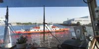
People always have used rivers for transportation. One of those rivers was and still is the river “Weser” through Bremen, a city in Northern Germany. At the beginning of the 19th century the “Weser” was so shallow that only small and light boats could reach Bremen on waterway. But this changed when Ludwig Franzuis deepened the river. From that time on also bigger boats could pass the “Weser”. Of cause this also had a big influence on the harbour of Bremen which grew rapidly and many new boatyards were build.On the panorama you can see the river “Weser” near Bremen-Vegesack where the first artificial harbour at a river in Germany was built in 1623. To cross the river to Lemwerder, you can swim or take the ferry boat which leaves every 10 min. by day.
So why do I have chosen this place for my panorama about transportation: In the region around the “Weser” you might still visit all these boats and dockyards which were so important and famous in the last century: The ship “Schulschiff Deutschland”, for example, sailed over the oceans to train young men as sailors. Now it has its berth at the old “Vegesacker Heerinsloggerei”, a factory where herrings have been loaded from board. On the other side of the river “Weser”, the traditional dockyard Aberking and Rassmussen is still one of the most successful boatyards: A ship constructed in this dock can be compared with a Rolls Royce.
I learned myself how to sail and swim in a small harbour, the “ Weser- Yacht- Club” in the 60s.
A little bit more upwards the river the famous transportation aircraft “Transall C-160 V2” was built. Its first flight was in 1963.
Downward the river “Weser” you can find the dockyard Franz Luersen where many ships are build nowadays. They focus on yachts, naval vessels and other special ships. The Franz Luersen dockyard was also charged to build the ships of the Deutsche Gesellschaft zur Rettung Schiffbrüchiger , the German SAR.
The panorama was made on the bridge of a ferry. The captains name is “Boje”. The German word “Boje” describes a small balloon used very often on water to warn sailors about dangers under water or to mark a special point so that the crew can find the position later again.
Equipment
Nikon D200, Sigma 8mm, custome made pano head, just a ball head handheld.
All pictures f8 1/100 sec at 100 ASA, RAW files, developed with RawShooter premium 2006, stiched with ptgui 6.01. Some very small corrections with CS2 and quicktime editing with pano2QTVR 1.2.10 pro.
 Tap or click the zoom icon in the bottom right corner of the picture to switch between in-page and fullscreen view