
Soil Transportation and Human Settlement
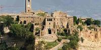
Civita di Bagnoregio, Viterbo, Italy
September 23, 2006 - h 14:30(local time)

Loading panorama viewer ...
Configuring ...
© 2006 Francesco & Leonardo Zan, All Rights Reserved.
Caption
This zoom-panorama is centered in Civita di Bagnoregio, a small hilltown in upper Latium , essentially medieval, rises in a landscape formed of volcanic tuff and badlands (clays). It is reachable by walking across a long pedestrian bridge over the badlands. Due to the isolation the city preserves its original medieval character.
Its debris are in the continuous process of transportation along the two main rivers down to the Tirrenian sea.
That soil-transportation, forms a continuous white belts (visible on the right side of the panorama), similar to large areas of New Mexico.
A large block of tuff is hanging down its side with a visible black vertical fracture on the far left part of the village (look for the descriptive hotspot in the interactive picture).
Note: This interactive picture has a total of 5 hotspot: 4 clickable hotspot and 1 non-clickable descriptive hotspot.
Scientific digression: In these areas where drainage density is high, surface erosion processes predominate where clays are present. A cap of consistent volcanic products preserve the site where the village is settled. In some places the volcanic cliff hill is mined to the base from the continuous erosion of small rivers and from the action of rains and the wind. The erosion and soil transportation is supposed to be in about 7 cm per year.
Location
Lat: 42° 37' 33.45" N
Long: 12° 6' 17.59" E
Elevation: 441 m
Precision is: Medium. Nearby, but not to the last decimal.
Equipment
Nikon D200 + MicroNikkor 105mm + Nikon Circular Polarizing filter + Manfrotto 303SPH
Behind the scene : Where and why this panorama was made
The Panorama was shot against a wall and framed between vegetation.
It was used a sharp medium telephoto lens with a circular polarizing filter to offer a high level of details towards the beautiful geological features and the village itself.
The point of view is almost at the same altitude of the village and offer the best perspective to show the front of the village with the two valleys that surround it.
 Tap or click the zoom icon in the bottom right corner of the picture to switch between in-page and fullscreen view