
Aboard the North Carolina Ferry Chicamacomico
Hatteras Inlet, North Carolina, USA
23 September 2006 08:06:43 hrs (GMT -4)

Loading panorama viewer ...
Configuring ...
© 2006 Gary O'Brien,
Some Rights Reserved.

Caption
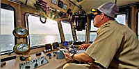
As the sun rises from the Atlantic Ocean, Captain Johnny King pilots the North Carolina Department of Transportation Ferry Chicamacomico across Hatteras Inlet.The inlet separates Ocracoke and Hatteras Islands on North Carolina's Outer Banks. The ferry is a part of NC Route 12, which extends the length of the Outer Banks.
The Chicamacomico is a Hatteras class ferry. Its gross tonnage is 275 tons, and it is capable of carrying 30 vehicles and 149 passengers. Its length is 150 feet, its beam is 42 feet and it draws 4 feet of water.
More about the North Carolina Ferry System:
http://ncdot.org/transit/ferry/routes/schedule/route003.html
I shoot panoramics and other multimedia for The Charlotte Observer:
http://www.charlotte.com/mld/charlotte/news/multimedia/
http://ncdot.org/transit/ferry/routes/schedule/route003.html
I shoot panoramics and other multimedia for The Charlotte Observer:
http://www.charlotte.com/mld/charlotte/news/multimedia/
Location
USA-Canada / USA-North Carolina
Lat: 35° 11' 50.3" N
Long: 76° 47' 22.52" W
Elevation: Sea Level
Precision is: High. Pinpoints the exact spot.
Equipment
Nikon D100; Sigma 8mm f/4 fisheye; Nodal Ninja 3 panoramic head; Amvona AT CF92 tripod; Marantz PMD660 digital recorder; Audio-Technica AT 897 shotgun microphone; Adobe Photoshop CS 2 RAW acquire; PTMac; Enblend; Cubic Converter; Audacity audio editor (sourceforge.net)
 Tap or click the zoom icon in the bottom right corner of the picture to switch between in-page and fullscreen view