

Loading panorama viewer ...
Configuring ...
© 2006 George Row, All Rights Reserved.
Caption
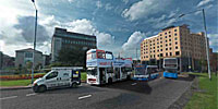
There once was a thriving port here, from which emigrants sailed for America, and through which much cargo passed. During World War II, when Lough Foyle provided a safe natural harbour and last stop before the North Atlantic, it is said that you could cross the river simply by stepping from ship to ship. Nevertheless Harbour Square in Derry is still a meeting place for many types of transportation. We have:
- a cycle route
- busses emerging from the bus station
- cars
- pedestrians
- the train across the river
- boats of various sorts
The white boat included in this VR is “The Toucan One” . It takes people on boat trips and parties down Lough Foyle from Derry Quay to the mouth of the river at Movile. That is the route taken by many emigrants to America in the 19th Century. So many so that they wrote songs about it!
Across the river can be seen the Belfast to Derry train arriving into Derry. It follows a dramatic coastal route via Coleraine and Castlerock.
Right next to us is part of the Foyle valley Cycle Route.
There are lots more VRs of Derry at: Very Derry
There are VRs from all over the country at: Very Ireland
Location
Lat: 54° 59' 56" N
Long: 8° 20' 9" W
Elevation: 0
Precision is: High. Pinpoints the exact spot.
Equipment
Taken with a Minolta DImage 7 digital camera, with a 7.2-50.8 mm f2.8 lens. Taken at a focal length of 7.2 (equivalent to 28mm). Mounted on a Kaidan Kiwi-L pano-head. Stitched using the Calico stitcher and rendered as a Cubic VR using ClickHere's Click this textCubic Converter
 Tap or click the zoom icon in the bottom right corner of the picture to switch between in-page and fullscreen view