
Turfrace
Tolhuissluizen, Nieuwveen, The Netherlands
September 22, 2006, 12:00 local time

Loading panorama viewer ...
Configuring ...
© 2006 Henk Keijzer, All Rights Reserved.
Caption
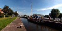
The Turfrace is an annual event bringing back the old times, when peat (in Dutch "turf") was used for heating houses. Vinkeveen (52°13'20 N, 4°56'00 E) was one of the areas in Holland, rich of peat and each year in autumn flat-bottomed vessels were transporting dried peat from there to all over Holland. So much peat was removed that lakes started to grow all around Vinkeveen. The Turfrace this year had 6 participants, racing from Warmond (52°11'50 N, 4°30"30 E) to Vinkeveen on Friday and racing back with a symbolical load of peat to Warmond on Saturday and Sunday. The skipper and his crew use wind, but more often muscle power, to cover the total course of over 100 km (62 miles). All is allowed except engine power. Along the route the ships need to pass several bridges and locks. In the panorama you can see the "Nostalgie" (twice) in the Tolhuis lock. The "Onderneming" (Enterprise) just left the lock and is sailing on to Vinkeveen.
Equipment
Hardware: Olympus E-300, Peleng 8mm fisheye, handheld, 10 shots. Software: Hugin, Photoshop elements, Pano2qtvr.
 Tap or click the zoom icon in the bottom right corner of the picture to switch between in-page and fullscreen view