

Loading panorama viewer ...
Configuring ...
© 2006 Holger Buhr, All Rights Reserved.
Caption
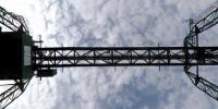
Since the roman times the Rhine has always been an important waterway for all kind of goods. Since the beginning of the 19th century many river regulations have been undertaken, so that nowadays the Rhine is the cheapest route of transport for cargo between Rotterdam and Basel. The Cologne ports are the second largest inland port location in Germany. The port of Niehl is the biggest in Cologne, in 2005 for example more than 400.000 TEU (equivalent to approx. 2.800.000 tons) of goods were transshipped with the help of four container bridges. The panorama has been realized under one of these bridges.
Location
Lat: 50° 58' 53.34" N
Long: 6° 58' 13.91" E
Elevation: 44 m
Precision is: High. Pinpoints the exact spot.
Equipment
Camera: Nikon D70s, F 8.0, 1/500 s, no tripodSoftware: PTGui, PanoTools, DeFish, Photoshop on a Mac G4, 350 MHz
 Tap or click the zoom icon in the bottom right corner of the picture to switch between in-page and fullscreen view