
Planes, Trains, & Automobiles
West Lothian, Scotland, UK
22nd September 2006 around 13:25

Loading panorama viewer ...
Configuring ...
© 2006 James Gentles, All Rights Reserved.
Caption
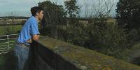
This isolated spot tells the history of Scotland's industrialisation and transport infrastructure. 200 years ago this cart-track was the only way to get about.Looking right: The bridge we are standing on was built in 1820 when the Union Canal brought industry to a rural landscape, carrying coal to the flourishing city of Edinburgh.
In the distance: The Bathgate and Coatbridge Railway was built in 1849, crossing the canal, and slowly stealing it's trade, sapping its life-blood.
Look up: After service in the First and Second World Wars "Turnhouse Aerodrome" became "Edinburgh Airport", the plane is on final approach.
Look over the gate on your left: In the 1960s the M8 Motorway was built. With no thought for the past it severed the cart track and canal, at this time the railway service ended.
But there is hope. In 1985 the railway re-opened, an early success for railways rebirth in the UK. In 2000 the canal also reopened, with access reinstated to this "green" corridor.
This is now a quiet place of recreation, not just boats but walkers and cyclists. Few consider it's place in the history of industrialisation and transportation.
(Note: The images for this shot were all taken within a 15minute period, although an isolated location, you don't have to wait long for the next plane, train, or automobile!)
www.gentles.ltd.uk
Equipment
Nikon 8400 with FC-09 Fisheye and homemade nodal mount
 Tap or click the zoom icon in the bottom right corner of the picture to switch between in-page and fullscreen view