
Megalithic Sites of Carnac - A Spiritual Transportation
Carnac, Morbihan, France
September 20, 2006 - 19:38 GMT (17:38 local time)

Loading panorama viewer ...
Configuring ...
© 2006 Jean-Marc Paratte,
Some Rights Reserved.

Caption
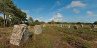
Back 6000 years...The Carnac alignments were builts in the Neolitic era, a period of prehistory which, for the Armorican massif, covers the time from 5000 to 2000 BC.
The Carnac alignments are the most famous and most impressive groups from this period, with nearly 4,000 standing stones (or menhirs).
Sites are closed to people because too many are walking in sites, there want to find and get the "mystic power" of this ancient tribe...
Equipment
D70 + Peleng 8mm + monopod + self-made panohead8 shots + 1 zenith, raw files, 16 bits process.
 Tap or click the zoom icon in the bottom right corner of the picture to switch between in-page and fullscreen view