

Loading panorama viewer ...
Configuring ...
© 2006 Michael Hansky, All Rights Reserved.
Caption
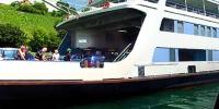
The ferry services on the 4.2-km route between Constance and Meersburg across Lake Constance exists since 1928.
The crossing takes approx. 15 minutes; during the day a ship departs from each side at least 4 times every hour.
The 6 operating ferries are crossing Lake Constance in excess of 61,000 times per year and carry:
- 5.3 mio. passengers
- 1.6 mio. cars
- 509,000 two-wheeled vehicles
- 79,000 commercial vehicles Lake Constance, surrounded by beautiful scenery, is Europe's largest drinking water reservoir, providing millions of people with their water requirements throughout the year.
www.bodensee360.de
 Tap or click the zoom icon in the bottom right corner of the picture to switch between in-page and fullscreen view