
Transporting Power
Near Callow End, Worcestershire, England, UK
September 24, 2006 - 13:58 UTC (14:58 Local Time)

Loading panorama viewer ...
Configuring ...
© 2006 Robert Bilsland, All Rights Reserved.
Caption
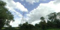
Without this sort of transportation where would the modern world be? With miles and miles of cables suspended on pylons criss crossing our countries, transporting electricity from power plant to sub-station and consumer. Some people think they are ugly while others see them as a thing of beauty (there is even the Pylon Appreciation Society).I chose this location as it had two power lines crossing each other heading off in different directions. This is weird as both of the lines end up at the same sub-station just a few miles away, one line taking the direct route while the other takes a more scenic route. The location wasn't too bad to get to, about a 20 minute walk across farmers fields and down overgrown paths.
Location
Lat: 52° 9' 24.84" N
Long: 3° 15' 17.04" W
Elevation: 55 ft
Precision is: High. Pinpoints the exact spot.
Equipment
Taken with a Nikon Coolpix 990 and a FC-E8 Fisheye lens. Mounted on a simple L shaped bracket. 4 portrait frames taken 90 degrees apart with the fisheye circle just touching the top and bottom of the frame, while being clipped on the left and right. Stitched using PTGui / Panotools and converted to a QTVR Cube using Pano2QTVR Pro.
 Tap or click the zoom icon in the bottom right corner of the picture to switch between in-page and fullscreen view