
Transit Station in Construction - Park and Ride Here!
Minnetonka, Minnesota, USA
September 24, 2006 - 7:20 PM

Loading panorama viewer ...
Configuring ...
© 2006 Scott Stillman, All Rights Reserved.
Caption
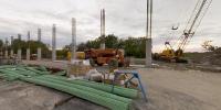
This is a Park and Ride facility in construction. Commuters will park here and ride a bus into downtown Minneapolis. This two level ramp is supposed to add 566 parking spaces and is replacing a flat parking lot that held 180 cars. According to Metro Transit, there are only 1026 parking spaces at Park and Ride facilities along this Highway 394 corridor that connects the Western suburbs to Minneapolis and St. Paul. Given that thousands of people commute daily from this area, it seems like there is much improvement to be made in our transit system and driving habits.There have been several efforts in the last decade to improve transit in this area including the construction of a special carpool lane that went mostly unused. After the carpool lane failed, it was recently converted into a carpool/Toll Lane that can be used by single commuters as long as they buy a permit. It sends a very different message when the goal is no longer cutting down the amount of cars heading into the city but rather “use the lane if you can afford it”. In addition, the electronic toll system is managed by a private company and the state sees little if any benefit. Estimates show a revenue somewhere between flat and 85% of the cost of operation.
I am a photographer and shoot mostly location work so of course I am still part of the problem. I do drive a Civic Hybrid, so at least I am a smaller part of it. I also avoid driving at rush hour (2:30 PM- 6:30 PM) like the plague.
Click here to see my Virtual Tour and Photography Web site at http://www.vrdigital.com/
Equipment
Nikon D1x, 10.5mm, Bogen 3021BPRO tripod, 303sph head, PTmac, Photoshop CS, converted to QTVR in Stitcher 4.0.4.
 Tap or click the zoom icon in the bottom right corner of the picture to switch between in-page and fullscreen view