

Loading panorama viewer ...
Configuring ...
© 2006 Stephen Hamilton, All Rights Reserved.
Caption
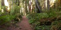
The Forest Path (walking)
The forest path has been the most commonly used method of transportation for the last 300,000 years.- Walking is an excellent use of energy.
- Walking is gentle on ecosystems.
- Walking is highly sustainable.
...and forests are good for the planet.
Location
Lat: 41° 23' 52.14" N
Long: 125° 2' 22.36" W
Precision is: Medium. Nearby, but not to the last decimal.
Equipment
Coolpix 995, Wide Converter WC-E63
 Tap or click the zoom icon in the bottom right corner of the picture to switch between in-page and fullscreen view