
Deer Lichens to Eat, Litter, and Evolve
Seagrove Beach, NW Florida, USA
2007, September 22 at 7:45 in the morning

Loading panorama viewer ...
Configuring ...
© 2007 Caroling Geary,
Some Rights Reserved.

Caption
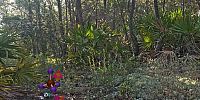
By the Emerald Coast, near Deer Lake State Park, leave the road and bike path to enter a small opening in the forest. Pine needles and lichens carpet the ground. Deer lichens are called "deer moss" locally and deer eat them for sustenance. See an external link to a photo of a deer eating deer moss below. Humans on TV shows Survivorman and Man vs. Wild used deer moss to eat. Look around for awhile and see other edible plants and garbage. People litter wherever they go with packaging of whatever sustains them, such as food, drink, or toys. Envisioning multiple symbiosis with deer lichens and evolutionary beings sustains my imaginative quest. For more info, click hotspots in the panorama to go to my website, wholeo.net.
Deer eating deer moss (external photo)
Background for the visions of evolutionary forms and multiple symbiosis
Larger version of this panorama (10 MB)
Background for the visions of evolutionary forms and multiple symbiosis
Larger version of this panorama (10 MB)
Much more about local deer moss/lichens at http://www.wholeo.net/Lookout/lookout2007/lookout07.html
Location
Lat: 30° 18' 18.5" N
Long: 87° 5' 22.5" W
Elevation: 20 feet
Precision is: High. Pinpoints the exact spot.
Equipment
Canon 300D (Digital Rebel) dSLR camera, EF-S 10-22mm lens, RAW. IS0 100. Nodal Ninja pano head. Background panorama is 12 exposures, each 1/4 sec at f/20. Focal length 20 mm. Photoshop CS3, Flash CS3, SketchUp, Freehand, and Swivel 3D for artwork. QuickTime VR Authoring Studio and QuickTime Pro for stitching and making panorama. Macintosh computer: Dual 2.7 GHz Power PC G5.
 Tap or click the zoom icon in the bottom right corner of the picture to switch between in-page and fullscreen view