
Desert Chromatics
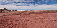
Painted Desert, Petrified Forest National Park, Arizona, USA
22 September, 2008 - 1801 Zulu (11:01AM Local MST)

Loading panorama viewer ...
Configuring ...
© 2008 David Schaubert, All Rights Reserved.
Caption
When it comes to the 'color' theme, northern Arizona presented many options; Sedona, Grand Canyon, Painted Desert, etc. As I had been looking for an excuse for a visit, I chose to use the opportunity to take a hike in the Painted Desert wilderness area. This is found in the northern part of the Petrified Forest National Park east of Holbrook, AZ.Most of deserts I have been in (Saudi Arabia, UAE, etc) display fairly monochrome sand dunes with the primary contrast resulting from variations in shade rather than color. However, the American southwestern desert is rockier and host abundant desert-adapted plant life. The Painted Desert is aptly named as the soils in this part of Arizona are tinted a veritable rainbow of colors by varying mineral deposits found in sharply stratified sediment layers. Over time, water erosion has cut down through the layers exposing the colors, and as a bonus, significant deposits quartz-based petrified trees from the late Triassic period.
The area that I hiked through is off the 'normal' tourist route through the park and once I was away from the trail down the cliff, I found no evidence of human activity. No trash, tracks, or trails. Only some crows and a jackrabbit.
I did encounter one thing unexpected; the intensity of the colors is highly dependent on the angle between the viewer, the terrain, and the sun. When viewing terrain towards the sun (south), the colors wash out to a grayish hue while to the north, the colors are vibrant. This is evident in the widely varying hues as the panorama is rotated.
If you are interested in the park, I did take an additional 30+ panoramas on this trip (and others) that can be viewed via the additional links area below.
For other panoramas from this trek through the Painted Desert (and other parks in the USA), see http://www.6t6kix.com/pages/vr_panoramas/panorama_parks.htm
For more information on Petrified Forest National Park, see http://www.nps.gov/pefo/ and/or http://en.wikipedia.org/wiki/Petrified_Forest_National_Park
For more information on Petrified Forest National Park, see http://www.nps.gov/pefo/ and/or http://en.wikipedia.org/wiki/Petrified_Forest_National_Park
Location
Lat: 35° 5' 30.21" N
Long: 110° 47' 57.89" W
Elevation: 1676
Precision is: High. Pinpoints the exact spot.
Equipment
Canon XTi (400D) DSLR, Peleng 8mm Fisheye Lens, Velbon VGB-3 Tripod, Nodal Ninja 3 Pano Head (NN3), Apple Macintosh 2.8 GHz Dual-Quad Xeon MacPro, PTGui Pro 8, Photoshop CS2, Cubic Converter 2.2.1, Cubic Connector 2.0.9
 Tap or click the zoom icon in the bottom right corner of the picture to switch between in-page and fullscreen view