
Where Color Made History
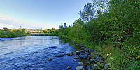
Marshall Gold Discovery State Historic Park, Coloma, California, USA
September 19, 2008, 6:05 PM

Loading panorama viewer ...
Configuring ...
© 2008 G. Donald Bain, All Rights Reserved.
Caption
When a miner sees gold at the bottom of the pan or sluice it is referred to simply as "color".In January 1848 James Marshall was inspecting a sawmill that had just been built, on the South Fork of the American River in the foothills of the Sierra Nevada mountains east of Sacramento. He saw something shiny in the turbulent water of the tailrace and fished it out. He walked around the gravel bar and picked up more of the shiny pebbles. They were nuggets of gold.
Efforts to keep the discovery secret failed and gold-seekers started heading to California from all over the world - the famous California Gold Rush. The 49'ers came overland in covered wagons, around Cape Horn in sailing ships from the east coast and Europe, and across the Pacific from Hawaii, China and Australia.
At the time of Marshall's discovery California was a remote province of Mexico with a population of less than 10,000. Two years later it had grown to over 300,000 and become an American state. The village of Yerba Buena became the city of San Francisco.
The stone wall in this photograph has a large bronze plaque on the other side commemorating that this is the actual spot at which the discovery was made. This is where Marshall's glimpse of "color" set in motion one of history's great events.
See more panoramas of California (and all of western North America) on my website: Don Bain's Virtual Guidebooks.
Location
Lat: 38° 48' 12" N
Long: 121° 54' 32" W
Elevation: 226 meters
Precision is: High. Pinpoints the exact spot.
Equipment
Photographed with an Olympus E-3 digital SLR with an 8mm Zuiko fisheye lens, on a Nodal Ninja VR mount, Acratec Ultimate Ballhead, and Velbon carbon-fiber tripod. Stitched with PTGui Pro 8 on a MacBook Pro 17" laptop, processed with PhotoMatix and Photoshop CS3, converted to QTVR using Cubic Converter.
 Tap or click the zoom icon in the bottom right corner of the picture to switch between in-page and fullscreen view