
Britain's Finest Baroque Church
St. Michael and All Angels Church, Great Witley, Worcestershire, England, UK
September 21, 2008 - 12:09 UTC (13:09 Local Time)

Loading panorama viewer ...
Configuring ...
© 2008 Robert Bilsland, All Rights Reserved.
Caption
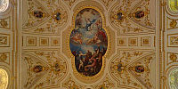
Once I knew the theme of this event, I knew where my panorama was going to be shot. I've visited this place many times before and every time the first step inside takes your breath away.The Church at Great Witley (or to give it its full name St. Michael and All Angels Church, Great Witley) is considered to be one of the finest Baroque churches in Britain. The place is awash with colour, from the white walls and gilded decorations throughout the church to the vivid colours of Antonio Bellucci's paintings and the backlit windows depicting scenes from the New Testament. This place is just full of bright and intense colours everywhere, there is gold in every direction.
I was hoping for a bright day to shoot the panorama, to try to get the best illumination for the windows, and I got my wish. The day was forecast to be warm and bright, so a trip out with my family was planned. The church itself is next door to Witley Court, a once impressive stately home, but now a rather well preserved ruin of it's former self in the care of English Heritage. A picnic was packed and my daughter invited one of her friends to come along with us for the day. By the end I had my panorama and everyone had had an enjoyable day around the court and church.
Location
Lat: 52° 16' 57.01" N
Long: 3° 21' 21.61" W
Elevation: 290 ft
Precision is: Unknown / Undeclared.
Equipment
Taken on a Nikon D300 with Nikkor 10.5mm f/2.8G Fisheye lens. Mounted on a Nodal Ninja 5 Lite panoramic head atop a Manfrotto 055XPROB tripod. 7 bracketed shots (-3, -2, -1, 0, +1, +2, +3) taken at 6 positions 60° apart, tilted 15° down and again another 7 bracketed shots taken looking straight up. Raw files then processed in Nikon CaptureNX 1.3 before being stitched / fused together using PTGUI 8.0.2 Pro / Smartblend 1.2.5 and converted to a QTVR Cube using Pano2VR 2.1.0. Final panorama was created with only 4 out of each of the 7 bracketed shots (-3, -2, +1, +3) to achieve the desired result.
 Tap or click the zoom icon in the bottom right corner of the picture to switch between in-page and fullscreen view