

Loading panorama viewer ...
Configuring ...
© 2008 Roger Hein, All Rights Reserved.
Caption
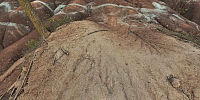
The Badlands are a rare and unusual sight in Ontario's geology. Iron oxide in the Queenston Shale is what gives this area its distinctive terra cotta colour. Light bands occur where the circulating ground water has transformed the iron oxide from red to green.My first visit to this site was over 35 years ago. Since then the area has seen an increase in urbanization. The dirt road leading to the Badlands has been replaced with asphalt. New housing developments have sprung up around it.
Once only known to locals the Badlands have become almost a tourist attraction. Every year thousands visit this site including bus loads of school children. Despite all this the Badlands remain much as I remember it. Currently it is under the care of the Bruce Trail Association.
www.rogerhein.com
Equipment
Hardware: Nikon D700, Sigma 15mm, Nodal Ninja 5L, Benro C257/Acratech V2 ballheadSoftware: 'Al' iMac 24", Capture NX2, Photoshop CS3, PTGui 8.0.2, Bracketeer 3.3, Pano2VR 2.1b
 Tap or click the zoom icon in the bottom right corner of the picture to switch between in-page and fullscreen view