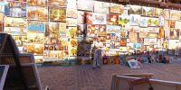

Paintings at Brama Florianska
Kraków (Cracow), Poland
September 19, 2009, 13:00 local time

Loading panorama viewer ...
Configuring ...
© 2009 Piotr Popik, All Rights Reserved.
Caption
It is not that easy in Kraków to find in one afternoon someone performing art (and eager to be photographed): it’s much easier to find people selling the art. Just near Brama Florianska (everyone who ever been in Kraków, seen it), one can buy pictures, not necessarily showing the old city. Interestingly enough, we have a nice conversation with the owner of the gallery about manual lenses for our cameras. More about this unique gallery. BTW, Marianna is now almost 3.5 years old.
Equipment
The panorama was taken with Peleng MC f 3.5/8 mm lens (set at f 8, 1 m) on Canon EOS 20D camera, (set at various exposure times), ISO 200). It was stitched with 5 images (4 around plus zenith) using Professor’s Helmut Dersch Panorama Tools (PTGui 4.1 graphical interface). Autopano and Enblend, as well as Gimp's ability to create Text Circle Logo were all of great help. I used 8 bit source images. Equirectangular image was converted to Quicktime with registered version 1.6.2 of Pano2QTVR Pro.
 Tap or click the zoom icon in the bottom right corner of the picture to switch between in-page and fullscreen view