
Beltany Stone Circle
Raphoe, County Donegal, Ireland, UK
September 19, 2011, 15:00 UTC (14:00 local time)

Loading panorama viewer ...
Configuring ...
© 2011 George Row, All Rights Reserved.
Caption
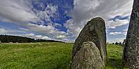
This panorama was shot at the Northwestern edge of the Beltany Stone Circle, which has stood for over 3,000 years on a small hill called "Tops" about 2km from the village of Raphoe.The Circle is roughly 45m in diameter and consists of 64 large stones, each between 1m and 2m tall, enclosing a low earth platform. There may have originally been as many as 80 stones. There is a single larger (2m+) standing stone to the South East of the main circle. That standing stone may have been a marker, which when aligned with the position of the sun or stars performed a calendar function of some sort.
The name comes from "Bealtaine", a Celtic festival marking the start of summer, traditionally celebrated around the 5-7th of May, the mid-point between the Spring Equinox and the Summer Solstice. The Celts of mainland Europe also celebrated what they called "Belotenia" at a similar stage in the year. In the modern calendar the shadow of Bealtaine probably lives on as May Day.
The mirror image of Bealtaine was the festival of "Samhain" (marking the mid-point between the Autumn Equinox and Winter Solstice). Falling at the end of October it lives on in the modern celebration of "Halloween."
Stone circles like this were built in the Bronze age (3,000-3,500 years ago). Their purpose is now unknown. Often people speculate that circles like this would have been associated with religious rituals but to my mind this could just have easily have been a Bronze Age night club or party venue.
Modern festivals are mostly about the associated party. So why should we expect that our ancestors were more concerned than we are with superstition or less concerned than us with having a good time.
Within other stone circles associated with Bealtaine archeological evidence has been found of large bonfires. Documents from from early Medieval Ireland (800–1166) record "Bealtaine fires" being lit throughout Ireland.
Certainly the location of Beltany Stone Circle, standing as it does in the centre of a saucer of low hills, would have been ideal for a beacon blaze that could be seen throughout the nearby countryside marking the date on the calendar—and inviting everyone for miles around to the party!
Prints of Beltany are available from my RedBubble pages.
Location
Lat: 54° 51' 5.11" N
Long: 8° 37' 15.08" W
Elevation: 90m
Precision is: High. Pinpoints the exact spot.
Equipment
Shot with a Canon EOS 5D, Zenitar 16mm fisheye f/2.8 lens. The camera was mounted on a Kaiden Kiwi panorama adapter on a Manfrotto 190XDB tripod.Horizontal photographs were taken at 60° angles and also a ground and sky shot. Each "shot" consisted of three bracketed exposures.
A total of 27 separate images were combined using Hugin in order to achieve this High Dynamic Range type result.
 Tap or click the zoom icon in the bottom right corner of the picture to switch between in-page and fullscreen view