

Loading panorama viewer ...
Configuring ...
© 2011 Landis Bennett, All Rights Reserved.
Caption
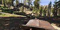
The High Sierra is a beautiful place to take a hike, and there are all kinds of things to find. Take this old rusted out car chassis. It was obviously used as a source of mechanical power for the nearby abandoned and closed up mine. Imagining what it must have been like as a miner out in the wilderness trying to rustle up some valuable minerals can take a hiker in to another world. These are some of the remnants of the Lost Cabin Mine.
Location
Lat: 38° 40' 51.8" N
Long: 121° 1' 55.6" W
Elevation: 8,549 ft
Precision is: High. Pinpoints the exact spot.
Equipment
Hardware: Nikon D200, Nikkor 10.5mm lens, Kaidan QuickPan III Speherical
Software: PTGui/Mac, Photoshop CS3, PanoPreviewer
 Tap or click the zoom icon in the bottom right corner of the picture to switch between in-page and fullscreen view