
The Mill Pond - Upper Canada Village
Upper Canada Village, Morrisburg, Ontario, Canada
June 21, 2007 at 1:00 PM ET

Loading panorama viewer ...
Configuring ...
© 2007 Robert Agnel, All Rights Reserved.
Caption
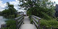
Upper Canada Village an 1860's Heritage Park located on the St. Lawrence River.The movie opens showing one of the foot bridges connecting the millpond water control dam with the chutes supplying water to the mills. Panning right we see Beach's Sawmill. Early settlers needed a constant supply of lumber, planks for building houses and barns, wood for furniture, barrels, and wagons. Water was gathered by damming a stream to create the millpond. This water was then directed against a power wheel, which operated the saw. Beach's Sawmill was capable of producing 2000 feet of board in 24 hours. The miller kept half the wood that was brought in, and sold it to other businesses. Today, this working sawmill produces planks (more than 2 inches thick) and boards (less than 2 inches thick) for use in the village and for sale to the public.
Next is Asselstine's Woollen Factory. By the 1840s water-powered woollen mills were common in Upper Canada. These mills were able to clean and card wool, spin it into yarn, and weave and fold cloth. The mill is presently used as a functional historical exhibit producing blankets and other textile goods.
Bellamy's Steam Flour Mill is the large stone building. The principal agricultural crop in Upper Canada was wheat. For the wheat to become useful it had to be ground into flour. The miller received grain from the local farmers, milled it to their specifications and returned it to them. As payment for his work he kept 1/12th of the wheat ground. Before 1863, the mill operated solely by water power. Water turned large stones, which ground the wheat into different grades of flour. Because the supply of water was limited, this meant the mill only ran efficiently for about four months of the year. In 1863 a fire destroyed the interior of the mill. Three months later, it was back in operation with new steam-powered machinery. Additional stones were also purchased. This meant that the mill could produce more flour at a time, and more importantly, could now operate all year.
The flour and saw mills provided a meeting place for farmers and tradespeople. Activity at the mills provided business opportunities for other entrepreneurs, hotel owners, storekeepers, tradesmen and professionals.
http://www.uppercanadavillage.com/
http://www.parks.on.ca/village/filmvil.htm
http://www.ontariotravel.net/TcisCtrl?site=consumers&key1=siteTools&key2=search&key3=listingDetail&listingId=13623&language=EN
www.ottawapanoramas.com
Location
Lat: 44° 56' 49.02" N
Long: 76° 5' 4.83" W
Elevation: 63 metres
Precision is: High. Pinpoints the exact spot.
Equipment
Nikon Coolpix 950, WC-E24, Kaidan KIWI head, tripod, Photosshop CS, QuickTime VR Studio
 Tap or click the zoom icon in the bottom right corner of the picture to switch between in-page and fullscreen view