

Loading panorama viewer ...
Configuring ...
© 2006 Markus Altendorff, All Rights Reserved.
Caption
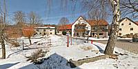
Höfling is one of many villages that sit atop a hill, but in this case the hill happens to separate Europe - the snow on the "side towards the car with the open trunk" will melt to flow towards the North Sea, while the snow towards the birch will end up in the Black Sea. This is part of the main European watershed, a not-so-imaginary line that separates the continent into parts where rivers run towards the Atlantic or the North Sea and the other half where the water flows towards the Mediterranean and the Black Sea.Apart from that, it seems i've crossed some territorial border - at least the dog kept on announcing my presence, so I guess I must've stepped on his ground. Oh, and there's a bird in the picture that kept on signalling that this was his area. Can you spot it?
Location
Lat: 49° 28' 31.37" N
Long: 11° 39' 39.35" E
Elevation: 480 m (appr.)
Precision is: High. Pinpoints the exact spot.
Equipment
Manfrotto 303 SPH, Canon EOS 20D, Sigma 18-125 @ 18mm, Stitcher 5.1, Photoshop.
Behind the scene : a good idea, and a timing waaay off...
Only when searching for some kind of border around my hometown did i learn that a huge natural border actually runs very near: the euopean main watershed is merely six kilometers away. It's nothing spectacular - with the highest "mountains" around 600 meters above ground, one wouldn't notice it right away. However, as some sort of attempted tourist attraction, signs like the one in the picture, saying "Rhine - Danube" started to pop up. And there actually is a church built on the watershed, so that half of its roof drains towards the North Sea and the other half of rain and snow flows towards the Black Sea. Trouble is, there was nothing about this to be found at the "usual suspects" like Google. The nearest thing to the water-splitting church was some 300 kilometer's drive away, which seemed a bit much for a single panorama. Though i remembered reading (actually typesetting...) the article a few years ago, i couldn't for the life of me recall where it was...End result: I picked one of the two possible locations with watershed signs that i knew of - between the villages of Höfling and Schönlind, Höfling was the lucky one. The Schönlind panorama would've compressed much better - there was little detail beside snow and sky, whereas Höfling does show an almost typical village scene for the region. Yes, that's really how empty it is on a sunday noon.
A friend later found the church i vaguely remembered, at the village of Poppberg some 20 kilometers away, but when i got there on the last day of the photography timeframe, the weather was less than stellar: heavy clouds and fog, so i decided to use the sunny sunday shot instead.
 Tap or click the zoom icon in the bottom right corner of the picture to switch between in-page and fullscreen view