
St. Paul Skyway
St. Paul, Minnesota, USA
March 23, 2012, 18:26 UTC (12:26 am local time)

Loading panorama viewer ...
Configuring ...
© 2012 Edward S. Fink, All Rights Reserved.
Caption
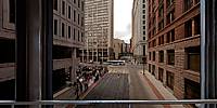
360 degree panorama in a St. Paul skyway over the Central Corridor Light Rail construction.The Twin Cities of Minneapolis and St. Paul have the coldest average temperature of any major metropolitan area in the U.S. Due to the extreme weather both cities have developed a system of enclosed, climate controlled pedestrian bridges linking the downtown buildings. The St. Paul skyway pictured here, is one of the largest skyway systems in U.S.
The Central Corridor Light Rail will connect the downtowns of Minneapolis and St. Paul.
The protesters in the courtyard plaza below are Catholics protesting President Obama's mandatory insurance funding for contraceptives.
Location
Lat: 44° 56' 48.81" N
Long: 94° 6' 22.08" W
Precision is: Medium. Nearby, but not to the last decimal.
Equipment
Nikon D700, Nikkor 10.5mm (shaved), Nodal Ninja Ultimate R1, PTGui, Photoshop
 Tap or click the zoom icon in the bottom right corner of the picture to switch between in-page and fullscreen view