
Central Experimental Farm
Ottawa, Ontario, Canada
September 19, 2007 at 16:00 ET

Loading panorama viewer ...
Configuring ...
© 2007 Robert Agnel, All Rights Reserved.
Caption
The
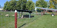
(CEF) Central Experimental Farm was established in 1886. The farm covers about 500 hectares (1250 acres) and is located in the middle of an urban area with a population of 1.2 million. Ottawa is the only world Capital with a working farm within its boundaries.The head offices for Agriculture and Agri-Food Canada are located on the farm as are many research facilities. The CEF is one of 18 agricultural research stations monitoring the different climates, topography, length of growing seasons, soil types and different crops that can grow in Canada. Most of the land is used for experimental field plots, where corn, soybeans, oats and other crops are grown. A large variety of domestic animals are also located on the farm. Beef and dairy cows, horses, sheep, chickens and other domestic animals found on Canadian farms are here and available for public viewing. The Arboretum and Ornamental Gardens are favourite spots for tourists and locals.
Canada's unique agricultural heritage is featured at the Agriculture Museum where you can explore the sights and sounds of Canadian farm life. The Museum features a working dairy barn with a mixed breed herd of 45 - 50 cows (an average sized herd for Ontario). The cows are milked twice a day and the milk is sold to the Dairy Farmers of Ontario which in turn sells it to local dairies. At the dairy, the milk is processed, packaged and distributed to grocery stores. More than 98% of all farms in Canada are family owned and operated.
The Central Experimental farm plays an important role in providing sustenance to Canadians and people around the world, with inexpensive healthy foods. Canada's food prices are among the lowest in the world.
Every day, Canadians consume or use something produced on farms. There are approximately 280,000 farms in Canada with 3% of Canadians living on farms. In 1930, Canada became more urban than rural (i.e. more than 50% of the population lived in cities). In 1900 one farmer could produce enough food to feed 7 - 10 people. Today a Canadian farmer can feed 90 people or more due to more efficient production methods.
Exports are very important to Canada, we export 40% to 50% of our gross agricultural production. Major exports are grains, red meats and oilseeds with major markets in the United States of America, China, Japan, eastern Europe and Russia.
The farm not only provides sustenance to humans. The Atlantic flyway runs down the Ottawa River. Every autumn millions of birds heading south for the winter stop to enjoy soya beans, corn and other crops left on the ground after harvesting.
http://geoimages.berkeley.edu/worldwidepanorama/wwp606/html/AlexMakienko.html
http://geoimages.berkeley.edu/worldwidepanorama/wwp305/html/RobertAgnel.html
Location
Lat: 45° 23' 14" N
Long: 76° 43' 37" W
Elevation: 60 m
Precision is: High. Pinpoints the exact spot.
Equipment
Nikon Coolpix 950, WC-E24 wide adapter, QuickTime Virtual Reality Studio, Photoshop CS2
City of Ottawa farming facts
One of Ottawa’s appeals is its marriage of urban sophistication with pure country charm. The city’s downtown core is surrounded by cozy neighbourhoods, and just beyond them lie fields and farmlands. It doesn’t take more than about 20 minutes in any direction to reach the country from the city, and there are many small villages and rural communities within easy commute to Ottawa. In fact, over 90% of the City of Ottawa is rural, providing a host of choices when you are looking for a rural lifestyle.
City of Ottawa rural farmsOttawa's rural area covers 2,230 km2, an area equivalent to 40% of the size of Prince Edward Island. It represents about four-fifths of the city's total land area. Rural Ottawa is made up of historic townships that were settled and incorporated before the existence of the original City of Ottawa. In 1852, Carleton County included the townships of Fitzroy, Gloucester, Goulbourn, North Gower, Huntley, March, Marlborough, Nepean, Osgoode, and Torbolton. Bytown, which was renamed Ottawa in 1855, was a separated town until 1969, when Carleton County became the Region of Ottawa-Carleton. The Region and the local municipalities were dissolved to create the new City of Ottawa in 2001.
Over time, the rural areas adjacent to the city core became increasingly urbanized. Between 1946 and 1950, large portions of Nepean and Gloucester Townships were annexed to Ottawa. In the 1970's and 1980's, Nepean, Gloucester and March became cities, the latter under the name Kanata. Cumberland, added from Russell County in 1969, became a city in 1999. And Goulbourn Township has experienced strong urbanization in Stittsville. Today's rural Ottawa includes the geographic townships of Fitzroy, Huntley and Torbolton (amalgamated as West Carleton in 1974), Marlborough and North Gower (amalgamated as Rideau in 1974), Osgoode, and rural Goulbourn, as well as rural portions of the former cities of Kanata, Nepean, Cumberland and Gloucester. Within the rural area there are twenty-six villages and numerous country lot subdivisions. Forty percent of the rural area's land is farmland. Agricultural revenue in Ottawa is greater than that of Toronto, Montreal, Vancouver, Edmonton and Calgary combined, and the city is the agricultural capital of Eastern Ontario. There are also sixteen industrial parks in rural Ottawa.
Rural Population As of mid-2005, rural Ottawa's population stood at 84,500. Since 2001 it has grown at a faster rate (8.5%) than the City of Ottawa's overall average (6.5%). The population is distributed as follows: • The • southwest (the former townships of Rideau and Goulbourn, minus Stittsville) is the most populated area with 26,000 people; • The southeast (the former township of Osgoode and the rural portions of the former cities of Gloucester and Cumberland, south of the Greenbelt and highway 417) is a close second, with 24,100 people; • The northwest (the former township of West Carleton and the rural portion of the former city of Kanata), is growing quickly and has 23,000 people; • The northeast (the rural portion of the former city of Cumberland north of highway 417) has the smallest population, 11,500. Of the total rural population of 84,500, about 4,000 (5%) live on farms, 45,000 (53%) in country lot subdivisions and scattered lots, and 35,500 (42%) live in one of the 26 villages. Ottawa's rural villages vary in size. There are small hamlets like Ashton, Galetta, Dunrobin, Kinburn, Kenmore, Fallowfield and Sarsfield, with less than 500 people. There are mid-sized communities, such as Vernon, Kars, Vars and Fitzroy Harbour that have between 500 and 1,000 people. There are larger villages with more than 1,000 but less than 3,000 people, including Munster Hamlet, Navan, Carp, North Gower, Cumberland, Metcalfe, Osgoode and Constance Bay. There are three very large villages, two of which (Manotick and Richmond) function as small urban cores, and one (Greely) as a mainly residential suburb with some specialized businesses. These three villages account for 40% of the combined population of all villages. The strongest growth rate among villages belongs to Greely. Its population has increased by 33.5% between 2000 and 2004. Richmond, Carp and Dunrobin have identical growth rates of 20% for the same period, tied for second. Cumberland Village (19.6%), Navan (18.8%) and Vars (17.2%) also had exceptional growth rates
As of 2001 there were 1,318 farms in Ottawa, about 10% fewer than the 1,455 counted in the 1996 census. The number of tenant farm operators remained unchanged, while the number of owner-operated farms dropped by 19%. Of 1,318 total farm operations in 2001, 769 were between 28 ha and 161 ha. The second-largest group, with 357 farms, were operations smaller than 28 ha. There were 192 farm operations 161 ha or larger, including 11 that were 647 ha or larger.
A total of 80,060 ha of farmland (66.5% of the total) is privately owned and operated. A further 35,746 ha (28.8% of the total) is farmland rented from other private owners, while 4,686 ha (3.9%) is rented from governments. The top six farm types in Ottawa are: dairy, cattle (beef), miscellaneous specialty, vegetable, field crops (excluding grain and oilseed) and grain and oilseed (excluding wheat).
Number of Farms by Major Products (With Farms Reporting Total Gross Receipts Greater than $2,499) City of Ottawa, 1986-2001
Quick Facts • A population of over 1.2 million makes the Ottawa region the fourth-largest urban area in Canada • Ottawa is home to such high tech giants as Nortel Networks, Alcatel, Cognos, Tundra, Cisco, MDS Nordion and Entrust • Our technology companies are complemented by Dell, MBNA Canada, ING Direct, Clarica and MD Management • Ottawa is also the home of government organizations such as the Government of Canada, Parliament, the Senate, and the Supreme Court of Canada • More than 1,800 advanced technology companies employ more than 76,000 people • With the highest-educated workforce in Canada, Ottawa has more engineers, scientists and PhDs per capita than any other city in the country • $3.7 billion CDN in venture capital was invested in Ottawa technology companies from 2000 to 2005 • With 90 per cent of Canada’s industrial telecommunications research and development conducted here, Ottawa is one of the world's top five sites for R&D • Canada's Capital region welcomes over 7.3 million visitors per year, who spend over $1.18 billion • According to Statistics Canada, families in Ottawa had the highest median incomes of any Canadian city in 2001 • Mercer Human Resources International recently placed Ottawa 18th in a survey of 200 cities worldwide for best quality of life. Another study by Mercer found that Ottawa is the least expensive major city in which to live in North America. • Languages spoken include English (50%), French (32%) and a host of other languages including significant capabilities in Spanish, Italian, Portuguese, Chinese and Arabic
As identified in Ottawa’s 20/20 economic strategy, as many as 10,000 jobs in the City’s overall economy are directly and indirectly related to agriculture. Farmland occupies about 40 per cent of the municipality's rural lands. Close to 300,00 acres is farmed by over 1,300 agricultural operations. Located on these extensive areas of good soil - totalling more than 120,000 hectares - is a mixture of cash crop and livestock farms producing agricultural products with a value in 2001 of over $150 million.
In addition to cash-crop operations and livestock, other agriculture related businesses include nurseries, tree farms, vegetables, fruits, organics, beekeeping, horse farms and stables, rare breed preservation, farm supply businesses, veterinarians, agronomists and specialty niche operations often relating to the agri-tourism industry.
It is estimated there are well over 200 rural tourism businesses within the City of Ottawa. Most visitors that frequent rural attractions are urban residents or tourists looking for opportunities to connect with the rural lifestyle. Whether it’s buying fresh produce at a farmers market, relaxing at a B&B, browsing through an antique shop, experiencing the excitement of an agricultural fair, or exploring a historic building, there is no shortage of activities in rural Ottawa for the day-tripper, tour group or vacationer. Agri-Tourism is a growing market niche in the City of Ottawa. It has become a way to diversify and increase the sustainability of the family farm. In addition to providing on farm jobs for family members and local residents, it is also a great educational opportunity to give visitors an understanding of where their food comes from. Getting up close and personal with a dairy cow, winding through a corn maze, or tasting an apple fresh from the tree, brings home the reality and importance of agriculture.
 Tap or click the zoom icon in the bottom right corner of the picture to switch between in-page and fullscreen view