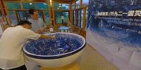

The Bowl of Regeneration, 碗若新生
Tao-Mi Eco-Village, Puli Township, Nantou County, Taiwan, 台灣 南投縣埔里鎮 桃米生態村
September 20, 2009, 09:58 UTC (17:58 TPE)

Loading panorama viewer ...
Configuring ...
© 2009 Walker Young, All Rights Reserved.
Caption
The performing is not only physical, but also in our mind..."Regeneration" and 921 Jiji Earthquake Community Reconstruction Photographic Exhibition
The 10th annual retrospect of the 921 Jiji Earthquake
Epicentre: 23.85°N 120.82°E
An unprecedentedly heaviest earthquake in the past century shattered Taiwan at 1:47 a.m. on September 21st, 1999.
The epicentre was in Jiji in Nantou county in central Taiwan with a hypocentre of 8 KM in depth, registering 7.3 on the Richter Magnitude scale.
The intense quake which lasted up to 102 seconds resulted in the dislocation of the Chelongpu Fault with a surface-faulting up to 80 KM in length, 2,455 deaths, and the whole-collapse of 50,652 houses.
The whole nation has thus begun the largest scale of "action of love" in history fully demonstrating the amazing vitality of the Taiwanese.
We witness the regeneration of the people and the land. —from the waste land(1922) by T. S. Eliot
「新生のごとし」及び921震災地域復興映像展
921集集大地震十年誌
震央:23.85°N 120.82°E
1999年9月21日、午前1時47分の深夜に、台湾では震度M7.3に至った、百年間で最大規模の地震が発生した。
震央は中部の南投県集集鎮に位置し、震源の深さは8kmである。
102秒も続いた強烈な震動はチェルンプ断層の変位を起こし、地表に長さ80kmに至った割れ目を残した。
これによって2,455人の命が奪われ、そして50,652件の建物が全壊した。台湾人は大規模な救援「愛の行動」を行い、復興再建まで驚くべきの生命力を見せた。
この土地とともに、廃墟から、人は新生した。
「碗若新生」暨921震災社區重建映像展
921集集大地震十年誌
震央:23.85°N 120.82°E
1999年9月21日凌晨1時47分,台灣發生百年來最大的地震,震央位於南投縣集集鎮,震源深度8公里,芮氏規模7.3。
102秒的強烈搖晃,造成車籠埔斷層錯動,地表破裂帶長達80公里,2,455人罹難,50,652棟房屋全倒。全國民眾展開有史以來最大規模的「愛的行動」,從救災到重建,充分展現台灣驚人的生命力。
人與土地,在廢墟中,新生。 * 引用自20世紀最偉大的一首英文詩,艾略特(T. S. Eliot)的《荒原》。
http://www.tripviewbowl.com/921.htm
"Regeneration" and 921 Jiji Earthquake Community Reconstruction Photographic Exhibition
「新生のごとし」及び921震災地域復興映像展
「碗若新生」暨921震災社區重建映像展
"Regeneration" and 921 Jiji Earthquake Community Reconstruction Photographic Exhibition
「新生のごとし」及び921震災地域復興映像展
「碗若新生」暨921震災社區重建映像展
Location
Lat: 23° 56' 30.55" N
Long: 120° 55' 38.98" E
Elevation: 470
Precision is: High. Pinpoints the exact spot.
Equipment
Canon EOS 5D + Sigma 8mm/f3.5, PTGui & Photoshop
 Tap or click the zoom icon in the bottom right corner of the picture to switch between in-page and fullscreen view