
Isonzo Front - Mrzli vrh WWI Landmark
Mrzli vrh, Posočje (Isonzo River), Slovenia
September 27th, 2014

Loading panorama viewer ...
Configuring ...
© 2014 Boštjan Burger, All Rights Reserved.
Caption
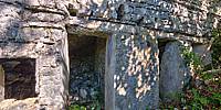
Ruins of the Italian shelter dug into the slope of Mrzli vrh. I found numerous caverns on the very steep slope just on the brink of the precipice of Mt. Mrzli vrh - some very well preserved even after 99 years.The Battles of the Isonzo (known as the Isonzo Front by historians, and "Soška fronta" by the territory's mainly Slovene population) were a series of 12 battles between the Austro-Hungarian and Italian armies in World War I mostly on the territory of present-day Slovenia, and the remainder in Italy along the Isonzo River on the eastern sector of the Italian Front between June 1915 and November 1917. In April 1915, in the secret Treaty of London Italy was promised by Allies (Great Britain, France...) the territory of Austro-Hungarian Empire which was mainly inhabited by ethnic Slovenes. Due the promised gift of Britain and France, Italian diplomacy betrayed Germany and Austro-Hungary and tried with the Italian army to penetrate in central Carniola, present-day Slovenia. The area of the Mt. Mrzli vrh (1358) was important strategic location and defense position of Austro-Hungarian Army to prevent Italian Army to invade the inner land of the monarchy. Due the fanatic attacks of Italian soldiers, threatened with the punishment and court-martial and wrathful defense of Austro-Hungarian soldiers, the battlefield on Mt. Mrzli Vrh was the bloodiest of all in the upper Soča Region. The The ridge was crisscrossed with numerous Austro-Hungarian and Italian trenches and caverns. Although with enormous casualties, the Italian Army never succeeded to break the defense. On October 24th Austro-Hungarian soldiers ignited the dreadful mine explosion inside the dug tunnel which ravaged the Italian platoon and opened the front line for the counter attack. It was the day when after 1.000.000 casualties and the 3 years Italian attempts with 11 massive frontal Italian attacks to Austro-Hungarian positions the united Austro-Hungarian and German troops with one single counter attack broke the frontline and pushed Italian the 2nd and 3rd Armies 90 km west to the Piave River. It was the day when the name of Slovenian town “Kobarid”, (Caporetto) became Italian synonym for the total defeat.
Location
Lat: 46° 13' 16.32" N
Long: 13° 40' 56.39" E
Elevation: 1138 m
Precision is: Unknown / Undeclared.
Equipment
Canon 5D camera, carbon tripod, 360 Precision Adjuste panohead, remote trigger. Method: tone mapping with 5ev (1.5 stop) exposures.
 Tap or click the zoom icon in the bottom right corner of the picture to switch between in-page and fullscreen view