It’s A Panorama Gallery
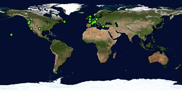
The WorldWidePanorama is a huge gallery of panoramic images that keeps being built from the contributions of more than one thousand photographers all around the world – amateurs and professionals alike. More panoramas are added every quarter, and every quarter has its own theme.
Learn more about the WWP ≫
It’s An Ongoing Event
Ever since the first event in 2004, the WorldWidePanorama has been open for all panoramic photographers, no matter if they contributed only once or if they stayed to become regular participants. Every three months, a theme is announced and all panorama photographers are invited to join and send in an image that they feel captures the theme’s spirit.
Learn more about participating ≫
View our recent Events
Exception Perception Best of 2025 Why Resilience Hidden Best of 2024 Wrinkle, December earlier (89 more) ≫The World Wide Panorama Social
facebook.com/TheWorldWidePanorama twitter.com/worldwidepano groups.io/wwp Google Earth KML for all events-
Share this page:
- Copy URL