
Höllentor
Below Alpspitze, Bavarian Alps, near Garmisch-Partenkirchen, Germany
September 26, 2009, 11:10 UTC (13:10 local time)

Loading panorama viewer ...
Configuring ...
© 2010 Carl von Einem, All Rights Reserved.
Caption
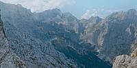
The past year brought me some really nice occasions to hike in the Bavarian Alps with dear friends. One of the most spectacular views from this particular trip, together with Marissa and Holger, was from a spot which is known under two different names, Höllentor and Rinderwegscharte:
- The first name literally means Hell's Gate, because the way down leads to the Höllental valley, which is a very rough area throughout winter due to the frequent avalanches coming down from all directions. If you follow the trail down to the valley and then left back up again over that small glacier, Höllentalferner, you will hopefully reach Germany's highest peak, Zugspitze.
- The second name describes the former main use, to drive cattle (= Rinder) over the trail (= weg) through the gap (= scharte) between the two peaks of the 2.628m/8.622ft Alpspitze and the 2.146m/7.040ft Höllentorköpfl. Yeah, right: cattle can climb up here in the high summer to reach the rich alpine pastures. The grass is just always better on the other side!
Location
Lat: 47° 26' 13.51" N
Long: 11° 2' 55.33" E
Elevation: 2100 m (6.890 ft)
Precision is: High. Pinpoints the exact spot.
Equipment
- Nikon D300 with Nikkor 8mm/2.8 Ai-S, six handheld shots (four around plus zenith and nadir)
- Hugin 2009.4.0, Photoshop
 Tap or click the zoom icon in the bottom right corner of the picture to switch between in-page and fullscreen view