

Loading panorama viewer ...
Configuring ...
© 2009 Jürgen Eidt, All Rights Reserved.
Caption
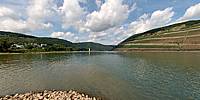
The Rhein-Nahe-Eck is where the river Nahe meets the river Rhein.The small light-yellow tower is the Mäuseturm: In 1298 the structure became an official customs collection tower. In 1689 it was destroyed by a French army, then rebuilt in 1855 as a Prussian signal tower. To the right is the Castle Ehrenfels, built in 1211.
The Rhein-Nahe-Eck forms the southern limit of the UNESCO Rhine Gorge World Heritage Site.
Equipment
Nikon D700 + Sigma 8mm f/3.5 on Nodal Ninja 3
 Tap or click the zoom icon in the bottom right corner of the picture to switch between in-page and fullscreen view