

Loading panorama viewer ...
Configuring ...
© 2006 Eva LaMar, All Rights Reserved.
Caption
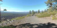
This cone is called “Lava Butte”. It rises 500 feet above the visitor center. This cinder cone erupted 7,000 years ago and covered over nine square miles with lava. The butte offers a panoramic view of central Oregon, including a spectacular view of the Cascade Range and the northwest flank of Newberry. The Lava Butte interpretive trail circles the crater rim. We walked this rim and were in awe of the geologic power that still exists today. One of the local eruptions changed the Deschutes River in three locations; each spot now sporting a waterfall or two. The blackness of the lava is in strict contrast of the trees surrounding the flow.The flow transported immense amounts of lava over the forest. Even modern-day transportation must work around the lava flow. Luckily, though, the lava is also used in making of the roads.
ELEVATION: 4500 feet
Location
Lat: 43° 54' 57.37" N
Long: 122° 22' 24.17" W
Precision is: Medium. Nearby, but not to the last decimal.
Equipment
Nikon D-70s with Nikon 10.5 lens, Panosaurus head, Bogen tripod. I used PT Mac to stitch, Photoshop to edit, and Cubic Converter for the final processing. This was my first panoramic created with this new software and camera.
 Tap or click the zoom icon in the bottom right corner of the picture to switch between in-page and fullscreen view