
Greater Moncton International Airport
Moncton, New Brunswick, Canada
2006/09/22 20:15 local time

Loading panorama viewer ...
Configuring ...
© 2006 Jean Berthélémé, All Rights Reserved.
Caption
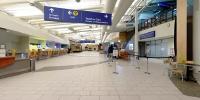
This panorama was taken during a brief period of calm between flights and under the watchful eye of at least one security guard (see image). With all the high security around airports these days, I was lucky to be able to capture the images without a lot of red tape and security procedures.The Greater Moncton area has a long history relating to transportation. In the early part of the 19th century Moncton was a centre for shipbuilding but when steam power and metal hull ships appeared that industry disappeared. A new era started when the Intercolonial Railway of Canada established its headquarters and major repair shops here. Through the years however railway operations diminished; the town was forced to reinvent itself yet again, which it did. In fact, its motto is "Resurgo" (I rise again).
The first scheduled air flight out of the Greater Moncton area took place on January 11, 1928. About a year later, the Moncton Aero Club started pilot training operations (it still operates today as The Moncton Flight College). In 1940, the Department of National Defence operated a flying training school here; the school trained war pilots from the Commonwealth countries. Various hangars and buildings were used by the growing airline industry, but in 1953 an air terminal worthy of this name was constructed and then expanded in 1964, 1976 and in 1999.
The Greater Moncton International Airport (code: YQM) is the province of New Brunswick’s only international airport. Built in 2002, the terminal has a surface area of 85,000 sq ft. The airport has two runways, 1,875 and 2,438 metres in length. In 2005, passenger traffic reached 535,624, more than all the other airports in the province combined.
Moncton has grown into a metropolitan centre together with the nearby towns of Dieppe and Riverview. Today Greater Moncton is a vibrant service centre and its airport is a major hub of people and cargo transportation in the Atlantic Canada region.
Greater Moncton International Airport /
Aéroport international du Grand Moncton
Website: http://www.gmia.ca/
Website: http://www.gmia.ca/
More panoramas on my website: http://www3.nbnet.nb.ca/jeanbert/
Location
USA-Canada / Canada-New Brunswick
Lat: 46° 6' 58.2" N
Long: 65° 42' 19.42" W
Elevation: 70.7 m
Precision is: High. Pinpoints the exact spot.
Equipment
I used a 12 mm lens on a digital SLR camera rotated on a custom-made panoramic head placed on a tripod. Eight vertical images were captured then stitched, corrected and saved as a QuickTime QTVR file. Angle of view is almost 90(v) by a full 360 (h) degrees.
 Tap or click the zoom icon in the bottom right corner of the picture to switch between in-page and fullscreen view