

Loading panorama viewer ...
Configuring ...
© 2006 Pat Rooney, All Rights Reserved.
Caption
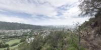
One of the more popular modes of transportation, your own two feets.A non-profit group, The Hawaiian Trail & Mountain Club, organizes hikes every weekend. Typically a dozen to several dozen hikers will show up to transport themselves to great views, waterfalls, and other areas of interest. The Sunday closest to this equinox was a ridge just above the valley I live in, Nu’uanu. I hoped to submit the pano taken at the peak of the four or five mile trail, but the clouds obscured the view we would have had of the Windward (eastern) side of the island. The hikers here are almost back to the trailhead after about nine miles and six hours of transport.
From this point you can see downtown Honolulu, Punchbowl Crater (now a military memorial) and the tallest buildings of Waikiki. Looking up the valley you can see rain looming, but today it never quite made it to town.
Location
Lat: 21° 20' 21.96" N
Long: 158° 51' 43.82" W
Elevation: 687m
Precision is: Medium. Nearby, but not to the last decimal.
Equipment
Canon EOS 300D with Canon 10-22 lens. Nodal Ninja 3 SPH-1 panoramic head.
 Tap or click the zoom icon in the bottom right corner of the picture to switch between in-page and fullscreen view