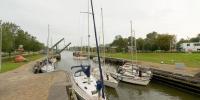

Lock of Hellevoetsluis
Hellevoetsluis, the Netherlands
24 September 2006 - 11:35 local time

Loading panorama viewer ...
Configuring ...
© 2006 Wim Koornneef, All Rights Reserved.
Caption
For many centuries water is the biggest way of transporting goods for trade between The Netherlands and other countries.Hellevoetsluis is one of the many small towns with his own harbor for this purpose. But Hellevoetsluis once also was a navy harbor. Almost all harbors that are at the coast of the North Sea have locks of the same kind that Hellevoetsluis has to maintain a high water level in the harbors at low tide. All locks also have a function to protect the inland from incoming salt water when the level of the sea water is at high risk level at times of storm and extra high tides.
Nowadays ships with trading goods and navy vessels are no longer passing the lock of Hellevoetsluis, just small boats for leisure are now entering the lock chamber. So once their main function was for trade and safety and now their main function is to protect the inland against salt water.
Website dmmdh: http://www.dmmdh.nl
Equipment
camera: Canon EOS 5D /
lens: Nikon 10.5mm fisheye /
panohead: 360Precision /
tripod: Manfrotto 755B /
wireless remote control: ZAPshot
More to see: Time lapse panorama movie of the lock
This WWP panorama is one of many panoramas that I shot of the lock of Hellevoetsluis.I used it with 42 others to make a Time lapse panorama movie.
The Time lapse panorama movie shows the moving of the lock gates, the bridge, the ships, the raising of the water and moving people in a 360x180 degree view.
You can see the movie at http://www.dmmdh.nl/WWP/wwp_092006/TimeLapsePanorama_Hellevoetsluis.html
I hope you enjoy viewing both my WWP participation as well as my Time lapse panorama movie.
 Tap or click the zoom icon in the bottom right corner of the picture to switch between in-page and fullscreen view