

Loading panorama viewer ...
Configuring ...
© 2004 Eldar Sharir, All Rights Reserved.
Caption
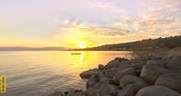
This Capernaum Virtual tour was taken between day & night, water & land in a place which represents both the old as well as the new era (the boat in the background is a traditional fishing boat), a place that is mentioned also in other then Jewish sources. Capernaum lies on the border between nature and man's world.Capernaum was in existence from the 2nd century B.C. to the 7th century A.D. Capernaum was built along the edge of the Sea of Galilee and had up to 1500 residents. Today the ruins are owned by two churches: the Franciscans control the western portion with the synagogue, and the Greek Orthodox's property is marked by the white church with red domes.
Around the beginning of the Common Era, the fishing village of Capernaum was entirely Jewish. It was very small. During the rule of Herod it guarded the frontier. A Roman garrison was stationed with a centurion at its head. Passengers had to pay taxes to a customs office. The centurion also seems to have ordered the building of the synagogue. The first synagogue does not exist anymore, but as archaeologists have shown in recent digs, it lies buried under the present synagogue.
The current synagogue was built sometimee in the fourth century. In the past it was thought that the synagogue dated from the third century. But now archaeologists argue that the correct date is late fourth century, because pottery and coins from the 4th century have been found under the floor.
The synagogue is made of white limestone, which was brought from quarries elsewhere. The usual material for the Galilee is black basalt. Its raised position on an artificial platform makes for greater impressiveness. The decorations are very elaborate, with lintels, cornices and capitals. The building is partly reconstructed, as many elements were found scattered in the surroundings.
The plan is similar to the one in Bar'am, but has a few more elements. There is a central prayer hall, a courtyard (here on the east side), a porch and a side room. The function of the side room is still being studied. The benches in the prayer hall only existed on two sides, instead of the usual three sides.
On the south wall of the prayer hall was a nave in which the Torah rolls were kept. Prayers were recited to this wall which faced towards Jerusalem. On both sides of the central entrance are the foundations of two bemas, elevated areas for reading the Torah. On the pavement of the synagogue, inside as well as outside, and also on the walls, several games are found, carved in the stone. They probably date from after the Arab conquest.
Some centuries later, in 629, the synagogue was destroyed by Christians. Fifteen years before that the Jews of Capernaum had destroyed the church. But full details about this are not known. Capernaum declined after the earthquake of 746 and it soon turned back into a fisherman's village.
The Middle East Peace Edition of the World Wide Panorama is a cooperative effort by VR photographers living in United Arab Emirates (UAE), Lebanon, Israel, and Egypt. We have organized, worked together and produced QTVRs that are linked together. Our message is clear, we cannot ignore each other any more since we all benefit from peace. This is our way to contribute to the Middle East peace efforts.
The members of this family are (in alphabetical order): Eldar Sharir (Israel), Fadi Saikali (Lebanon), Loyd Almeda (Dubai), Rana Mahmood (Dubai), Samir Ahmed (Dubai), Waleed Nassar (Egypt) and Yaniv Sirton (Israel). Thanks go to all participants for contributing to this effort, to Samir Ahmed for designing and wiring the flash in our QTVR's, and to Waleed Nassar for coming up with the idea of this edition.
Take a look at my panorama homepage!
 Tap or click the zoom icon in the bottom right corner of the picture to switch between in-page and fullscreen view