
Calm after the Storm
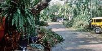
My Residence Hit By The Worst Typhoon In Memory, Philippines
10am sept28 2006

Loading panorama viewer ...
Configuring ...
© 2006 Benigno T Toda III, All Rights Reserved.
Caption
Manila lost a lot of 100-year-old trees.
Location
Lat: 14° 32' 57.95" N
Long: 121° 1' 54.54" E
Elevation: 77 ft.
Precision is: Medium. Nearby, but not to the last decimal.
Equipment
used a seitz roundshot (film 120mm) it takes a 360 pano so 1sticth is nessesary scanned in a drum scanner then stiched it this time with the vr works software
 Tap or click the zoom icon in the bottom right corner of the picture to switch between in-page and fullscreen view