Micro Panorama Thumbnail for Social Sharing Sites

Best of 2013

(January 1st — December 31st, 2013)

Andrew Bodrov

Mars Panorama - Curiosity Rover: Martian Night

Robert Bilsland

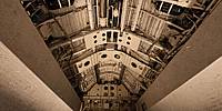
Once Proud Protector of Our Nation

Imperial War Museum Duxford, Cambridgeshire, England, UK

14 July 2013, 12:09 UTC (13:09 local time)

Loading panorama viewer ...
Configuring ...

© 2013 Robert Bilsland, All Rights Reserved.

Help
Caption
Once this mighty bomb bay would have been filled with a "Blue Steel" nuclear missile, but now it stands empty and open for all to see. The Avro Vulcan is a jet-powered, delta wing strategic bomber that formed part of the United Kingdoms V-Force bomber fleet. It has a wingspan of over 30 meters, is powered by 4 Bristol-Siddeley Olympus engines, can fly up to 55,000 feet, has a top speed of Mach 0.96 and a crew of 5. The bomber fleet was made up of Valiant, Vulcan and Victor aircraft with the Vulcan providing the backbone of the UK's nuclear airborne deterrent during the cold war.

They were in service with the Royal Air Force between 1956 and 1984 and provided many roles. One of their last roles was in Operation Black Buck during the Falklands war. Their capabilities were stretched to the max delivering conventional bombs to targets on the Falkland Islands while operating from the Ascension Islands, a round trip of over 7,800 miles.

After they were retired from service many were taken into museums and put on display like XJ824 here at Duxford. While it is great to see these class of aircraft you really do not appreciate their scale until you really get up close to them. Out of all of the remaining aircraft there are two which are in taxiable condition (XL426 and XM655) and one which is currently airworthy (XH558 - "The Spirit of Great Britain"). It is used for display flights and air shows and is truly a sight and sound worth experiencing for yourself.
Imperial War Museum Duxford
Operation Black Buck (Wikipedia)

www.panoview.co.uk
Location

Europe / UK-England

Lat: 52° 5' 48.96" N
Long: 0° 8' 12.44" E

Elevation: 108 ft

→ maps.google.com [EXT]

Precision is: High. Pinpoints the exact spot.
5 km
5 mi
Leaflet | Map data © OpenStreetMap contributors
Equipment
Taken with a Nikon D300 and a Nikkor 10.5mm f/2.8G fisheye lens. Mounted on a Nodal Ninja 5 panorama head and R-D16 rotator atop a Manfrotto 055XPROB tripod. Shots taken at 6 positions 60° apart, tilted 15° down and another shot taken looking straight up. Raw files then processed in Adobe Photoshop Lightroom 5.2 before being stitched together using PTGui Pro 9.1.8 and converted using Pano2VR 4.5beta.

PLEASE RESPECT THE ARTIST’S WORK. All images are copyright by the individual photographers, unless stated otherwise. Use in any way other than viewing on this web site is prohibited unless permission is obtained from the individual photographer. If you're interested in using a panorama, be it for non-profit or commercial purposes, please contact the individual photographer. The WWP can neither negotiate for, nor speak on behalf of its participants. The overall site is copyright by the World Wide Panorama Foundation, a California Public Benefit Corporation. Webdesign © by Martin Geier www.geiervisuell.com