The most popular association people make with the gold mines is the city of El Dorado. According to the legend, the Spanish explorers of South America encountered many people that wore gold jewelry and used gold products in their daily lives. There arose a myth of a gold city, which according to the legend, was located somewhere on the border of modern Columbia and Venezuela. This story of El Dorado drew the Spaniards deep into the heart of the continent. Although El Dorado has never been found, variations of the legend can still be heard across the land of Venezuela.
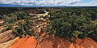
Only upon our return home, we found out we were circling over one of the major gold mines. They have open-pit gold mining here, which explains its bright red clay. Gold miners live in the village, located directly at the borders of the mine. It's called Ciudad Dorada. Sounds very much like El Dorado, doesn't it?
And although I did not see the Golden City, I am glad that the flight over the mines went well. Perhaps the miners were tired of working at the 40° C heat and the humidity of the jungle or the rain scared them off (the rain that came with a rainbow). Or perhaps our pilot did his job well to earn the tip. But no one even paid attention to us, so we finished our photo shoot in one piece.
The only bad feeling I still have is the destroyed rain forest. Miners cut off huge areas of the native forests. Unfortunately it happens almost everywhere these days.


 Tap or click the zoom icon in the bottom right corner of the picture to switch between in-page and fullscreen view