

Loading panorama viewer ...
Configuring ...
© 2008 Koen Verschaeren,
Some Rights Reserved.

Caption
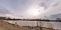
The Rupel is a tidal river in Flanders, Belgium. It is about 12 km long. It is formed by the confluence of the rivers Dijle and Nete, in Rumst.
It flows into the Scheldt at Rupelmonde.
The Rupel is part of the waterway to Brussels.
The panorama shows the confluence of the rivers Dijle and Nete.
Location
Lat: 51° 4' 30.1" N
Long: 4° 25' 12.53" E
Precision is: Medium. Nearby, but not to the last decimal.
Equipment
Olympus E3Olympus 8mm
Nodal Ninja 5
Bracketeer
Autopano Pro
Pano2VR
 Tap or click the zoom icon in the bottom right corner of the picture to switch between in-page and fullscreen view