

Loading panorama viewer ...
Configuring ...
© 2011 Tom Merchant, All Rights Reserved.
Caption
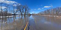
The Minnesota River overflows road high water limit due to Spring flooding, closing HWY 101 in Shakopee to some 24,000 vehicles that cross daily. Commuters are reaching their frustration and financial limits as detours add as much as 40 additional miles on to their drive. This river crossing was closed 20 days last Spring and 17 days in the Fall due to flooding. At the time this photograph was taken the water level was at 715’ which is 7’ over flood stage and expected to peak in the next couple days.
Location
Lat: 44° 48' 10.82" N
Long: 94° 32' 42.64" W
Elevation: 715
Precision is: High. Pinpoints the exact spot.
Equipment
Nikon D80 camera, Sigma 8mm lens, Nodal Ninja rotator, Manfrotto 3444 tripod.
 Tap or click the zoom icon in the bottom right corner of the picture to switch between in-page and fullscreen view