

Loading panorama viewer ...
Configuring ...
© 2012 Gerardo A. Sanchez, All Rights Reserved.
Caption
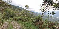
Path to the heightsWe live in a area that is surrounded by high mountains, the highest in my country. There are many paths around that drive you high into the mountains and it is pretty easy go higher than 4,000 mts (over 13,000 feet) by car even without a 4x4 truck. The place where we took this picture is over 2,000 mts (6,500 feet) and, as you can see, rainforest is all around. Down in the distance is a small town called Tabay.
Location
Lat: 8° 38' 37.55" N
Long: 72° 6' 0.62" W
Elevation: 2100 mts asl
Precision is: Unknown / Undeclared.
Equipment
Nikon D7000, Sigma 8mm, Nodal Ninja panohead. Software: PanoTools, PTGui, Adobe Photoshop CS5.
 Tap or click the zoom icon in the bottom right corner of the picture to switch between in-page and fullscreen view