
So Many Directions, But Which One to Take
Malvern Hills, Worcestershire, England, UK
March 18, 2012, 15:08 UTC (15:08 local time)

Loading panorama viewer ...
Configuring ...
© 2012 Robert Bilsland, All Rights Reserved.
Caption
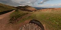
The Malvern Hills is a range of hills, sitting on the border between the counties of Herefordshire and Worcestershire. They are about 8 miles long and run almost perfectly north–south. They are designated as an Area of Outstanding Natural Beauty (AONB) by Natural England on behalf of the United Kingdom Government. An AONB is an area of countryside that is considered to have significant landscape value, and the hills definitely have that.Now paths are things that crisscross the hills in every which way, sometimes linking high points together, sometimes just taking a flatter and easier route. Not all paths are equal, some are little tarmac roads, allowing emergency services access to the harder reaches of the hills while others are nothing more than animal tracks, left by creatures taking their regular routes from point A to point B.
My only choice now is which one to take. I could take the steep path up to the Worcestershire beacon, I could take the flatter path round the north hill, or I could head down to St Ann's well, but which path is which. Well that’s easy, just look down.
Location
Lat: 52° 6' 31.87" N
Long: 3° 21' 23.21" W
Elevation: 1105 ft
Precision is: High. Pinpoints the exact spot.
Equipment
Taken with a Nikon D300 and a Nikkor 10.5mm f/2.8G fisheye lens. Mounted on a Nodal Ninja 5 panorama head and R-D16 rotator atop a Manfrotto 055XPROB tripod. Shots taken at 6 positions 60° apart, tilted 15° down and another shot taken looking straight up. Raw files then processed in Adobe Photoshop Lightroom 3.6 before being stitched together using PTGui Pro 9.1.3 and converted using Pano2VR 3.1.4.
 Tap or click the zoom icon in the bottom right corner of the picture to switch between in-page and fullscreen view