
Xeriscape Decade Part 2
Fort Worth, Texas, USA
20 March 2014 4:15pm Central Texas Time UTC -6

Loading panorama viewer ...
Configuring ...
© 2014 Pat Albright, All Rights Reserved.
Caption
[Quoted text found on the WWP home page and repeated here for the 10 year anniversary.]"The World Wide Panorama events were originally sponsored by the Geography Computing Facility at the University of California at Berkeley, and hosted by The Geo-Images Project. The WWP is now run by the World Wide Panorama Foundation, a California Public Benefit Corporation.
This is a non-commercial project, done simply to create enthusiasm for VR photography, and provide an outlet for our collective creativity. "The World Wide Panorama events were originally sponsored by the Geography Computing Facility at the University of California Berkeley, and hosted by The Geo-Images Project. The WWP is now run by the World Wide Panorama Foundation, a California Public Benefit Corporation.
This is a non-commercial project, done simply to create enthusiasm for VR photography, and provide an outlet for our collective creativity." Congratulations WWP Team.
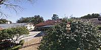
2004 was the year we designed and placed our Xeriscape Garden. Xeriscape is pronounced 'Zer-i-scape'. It incorporates seven basic principles which lead to saving water. 1. Planning and design 2. Soil analysis 3. Practical turf areas 4. Plant selection 5. Efficient irrigation 6. Use of mulches 7. Maintenance.
Our 6,400 sq feet (730 sq meters) Xeriscape garden was designed by a Landscape Architect and the installation was completed by a Master Gardener in 2004. Ten years later, the native Texas Evergreen plantings have survived drought and hard freezes. The light brown area is Southern St Augustine. It is dormant. With a little bit of rain it will turn green again. It lives on just like the WWP.
Location
Lat: 32° 39' 37.7" N
Long: 98° 23' 16.91" W
Elevation: 798 (780 + 18 pole) feet (266 m)
Precision is: High. Pinpoints the exact spot.
Equipment
Dell All in 1 64bit Intel i7 27" Touch Screen, Canon 5d, Sigma 8mm fisheye, Agnos MrotatorH Fiberglass Telescoping Pole, 488RC2 Ballhead, Nodal Ninja Ultimate R1 and EZ-Leveler II, Photoshop CS6 (non Cloud) Adobe Camera Raw 8.3, tilted up 5° - 4 full sensor frame raw images, PTgui Pro 64bit 9.1.9, Pano2vr Pro version 4.5beta2 64bit Image Converter.
 Tap or click the zoom icon in the bottom right corner of the picture to switch between in-page and fullscreen view